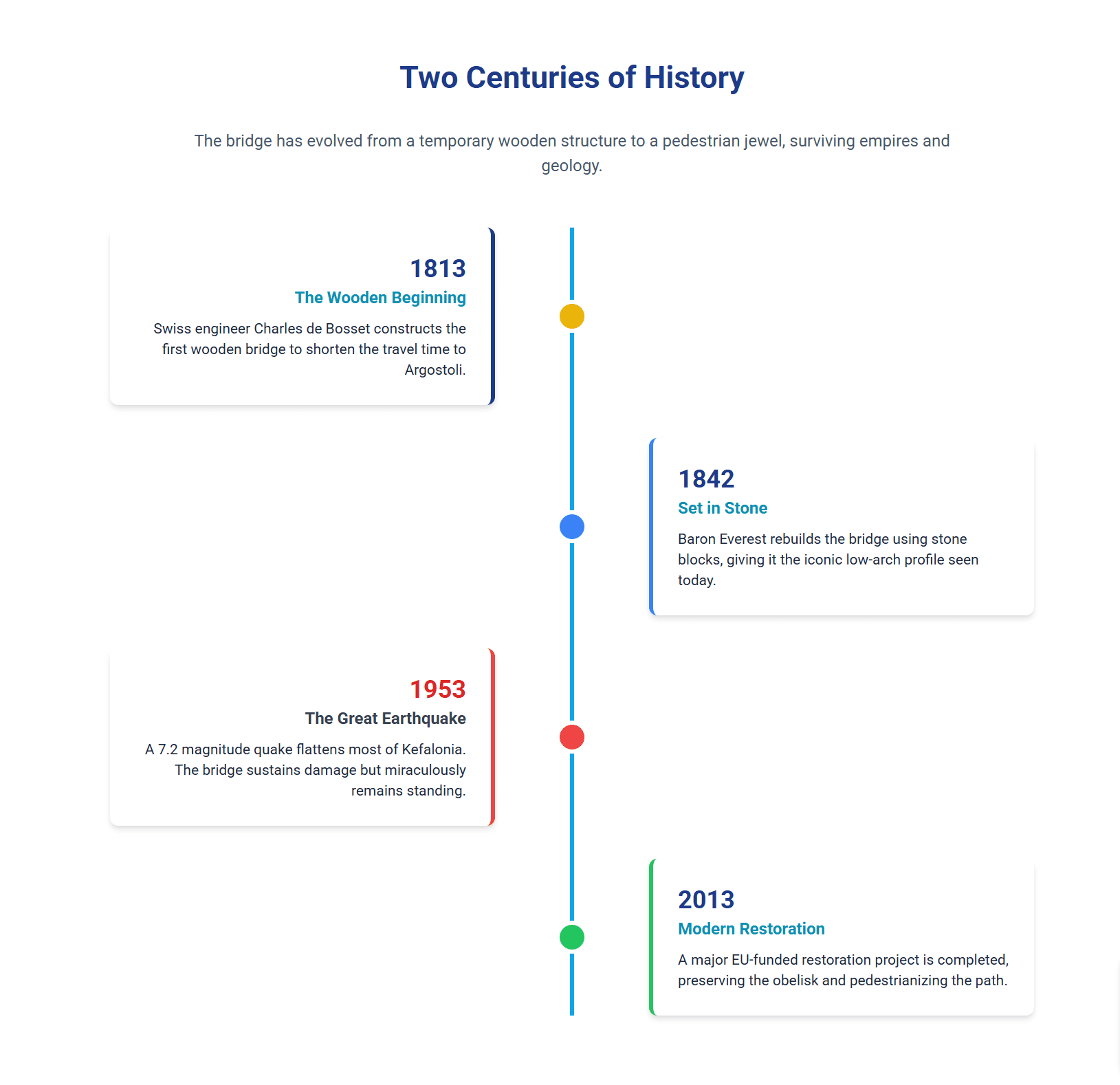
Stretching across the calm waters of the Koutavos Lagoon, the De Bosset Bridge is more than just a connection between Argostoli and Drapano. It is a testament to 19th-century engineering, a survivor of catastrophic earthquakes, and a vibrant sanctuary for marine life. Originally built of wood in 1813 by Charles de Bosset, it was solidified into stone in 1842, creating a permanent landmark that defines the island’s capital.
Introduction: The Stone Spine of Argostoli
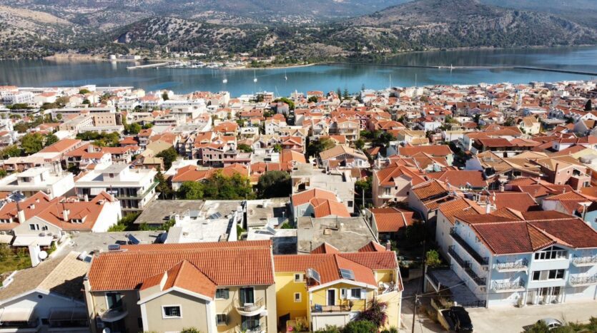
The De Bosset Bridge (Γέφυρα Ντε Μποσέ), situated in the vibrant capital of Kefalonia, Argostoli, stands as a monumental testament to the intersection of British colonial ambition, Greek craftsmanship, and the resilient forces of nature in the Ionian Sea. Spanning a distance of approximately 690 meters across the Koutavos Lagoon, it holds the distinguished title of the longest stone bridge over a marine body in existence, a record formally acknowledged by global record-keeping organizations.1 However, to view the De Bosset Bridge merely as a transit corridor or a statistical superlative is to overlook its profound role as a cultural and ecological axis. It is the spine of the capital, a structure that not only physically linked the administrative center to the rural interior but also metaphorically bridged the gap between the insular isolation of the 19th century and the interconnected tourism economy of the 21st.
For the travel writer or historian documenting the Ionian experience, the bridge offers a narrative richness that transcends its masonry. Today, stripped of vehicular traffic and restored to a pedestrian promenade, it serves as a serene observation platform for the Koutavos wetland, a sanctuary where the threatened Loggerhead sea turtle (Caretta caretta) navigates the shallow, seagrass-rich waters beneath arches constructed during the Napoleonic era.
Geopolitical Framework: The British Protectorate and the Ionian State
The Strategic Imperative of the 19th Century
To understand the genesis of the De Bosset Bridge, one must first situate Kefalonia within the volatile geopolitical landscape of the early 1800s. The Ionian Islands, guarding the entrance to the Adriatic and the strategic routes to the Ottoman East, were a prize contested by European powers. Following centuries of Venetian rule and brief, turbulent interludes of French and Russian occupation, the British established the “United States of the Ionian Islands” (a protectorate) in 1809, formalized by the Treaty of Paris in 1815. This period, lasting until the islands’ unification with Greece in 1864, was characterized by a rigorous program of modernization and infrastructure development, driven by the British need to secure their naval dominance and facilitate efficient colonial administration.
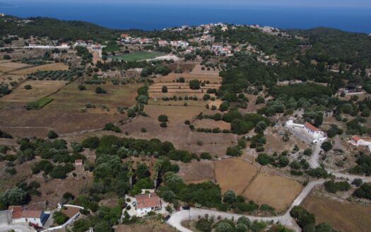
Argostoli, chosen as the capital of Kefalonia in 1757, suffered from a critical geographical flaw. Located on the tip of the slender Fanari peninsula, the town was commercially and logistically isolated from the main body of the island. The Koutavos Lagoon, a marshy inlet at the head of the bay, separated the administrative center from the village of Drapano and the crucial road networks leading to Lixouri and the north. For residents and traders, reaching the town meant either a perilous journey through the malaria-infested marshes surrounding the lagoon or reliance on small, unstable boats to ferry goods across the bay. This separation stifled economic growth and left the capital vulnerable, necessitating a permanent engineering solution.
Charles Philippe de Bosset: The Engineer Governor
The catalyst for change arrived in the form of Colonel Charles Philippe de Bosset, a Swiss engineer employed by the British Army. Appointed as the Governor of Kefalonia in 1810, De Bosset brought a Continental approach to military engineering and urban planning. Unlike traditional military governors who focused solely on fortification, De Bosset was preoccupied with civil connectivity. He recognized that for Argostoli to function as a viable capital, it required a “umbilical cord” connecting it to the hinterland.
De Bosset’s vision was holistic. He argued that a bridge would not only solve the transportation crisis but also address the public health emergency posed by the lagoon. By constructing a causeway, he aimed to regulate the water flow and separate the stagnant, mosquito-breeding marshes of Koutavos from the cleaner, tidal waters of the Argostoli Gulf. This dual-purpose design, transport infrastructure as sanitary engineering, was advanced for its time and reflected the Enlightenment ideals of rational governance.
The “Sword on the Table”: Colonial Will vs. Local Resistance
The proposal to span the lagoon was not met with universal acclaim. Historical records detail a fierce opposition from the local municipal council and the broader peasantry. The objections were twofold. First, the economic burden of such a massive construction project was deemed prohibitive for an island economy still recovering from wartime disruptions. Second, and perhaps more telling of the social anxieties of the era, there was a widespread fear that a bridge would compromise the town’s security. The lagoon served as a natural moat; bridging it, critics argued, would provide a “highway for thieves” and brigands from the unpopulated northern coast to raid the wealthy merchant homes of Argostoli.
The resolution of this conflict has become a defining legend of Kefalonian history. In a climatic meeting with the dissenting council in 1812, faced with endless bureaucratic obstruction, De Bosset reportedly drew his sword and struck it violently upon the table. He proclaimed that he would cut through the “petty concerns” of the locals just as he would cut the Gordian knot of their isolation.


Phase I: The Wooden Prototype (1813)
Construction of the bridge began in 1813. To mitigate costs and demonstrate immediate utility, De Bosset opted for a wooden trestle structure. Utilizing local timber and conscripted labor, the initial causeway was completed in an astonishingly short timeframe, cited in historical accounts as merely two weeks. This rapid deployment was a tactical masterstroke. By immediately opening the route, De Bosset proved the bridge’s economic viability to the skeptical populace. Traffic flowed, trade increased, and the fear of invasion proved unfounded. However, the wooden structure was inherently provisional. The humid, saline environment of the lagoon accelerated rot, and the increasing weight of commercial carts necessitated constant repairs, setting the stage for the monumental stone transformation that would follow.
Table 1: Timeline of Political and Structural Evolution
| Year | Event | Key Figure | Significance |
| 1810 | De Bosset appointed Governor | Charles de Bosset | Initiation of infrastructure modernization plan. |
| 1812 | The “Sword on the Table” | Charles de Bosset | Overcoming local opposition to the bridge. |
| 1813 | Construction of Wooden Bridge | Charles de Bosset | First direct link established; completed in ~2 weeks. |
| 1813 | Erection of the Obelisk | Kefalonian Parliament | Symbol of gratitude to the British Protectorate. |
| 1842 | Reconstruction in Stone | Baron Everton | Replacement of wood with limestone masonry. |
| 1864 | Union with Greece | N/A | End of British rule; inscription erasure follows (1865). |
| 1953 | Great Ionian Earthquake | N/A | Major structural damage and subsidence. |
| 2005 | Restoration Project Begins | Greek Ministry of Culture | Removal of concrete, stabilization of foundations. |
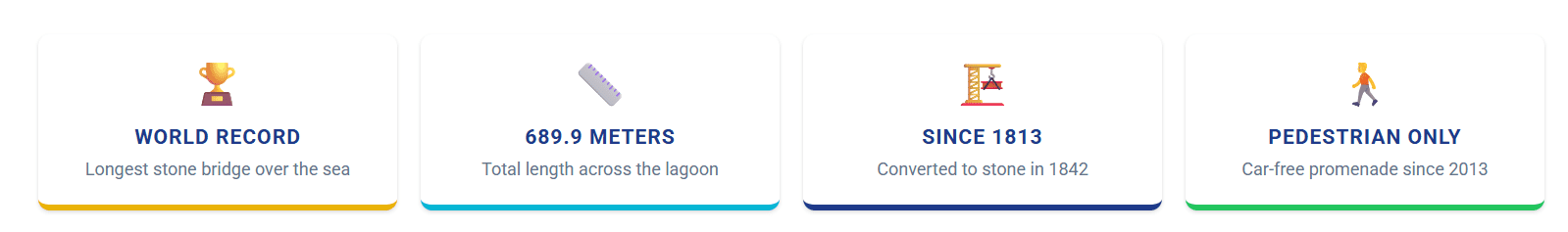
| 2018 | World Record Certification | Official World Record | Certified as longest stone bridge over sea. |
Defining the World Record
The claim of being the “Longest Stone Bridge over the Sea” requires precise definition. Many bridges are longer, and many cross water. However, the De Bosset Bridge is unique in its continuous masonry construction spanning a saltwater body. Unlike modern causeways built of concrete or steel piles, the De Bosset is a gravity structure relying on the weight of its stone blocks.
- Total Length: 689.9 meters (approx. 2,263 feet).
- Verification: This record was officially certified by the “Official World Record” organization in 2018, distinguishing it from the Lake Pontchartrain Causeway (concrete) or various river bridges in China. It stands as a singular example of 19th-century maritime engineering surviving into the modern era.
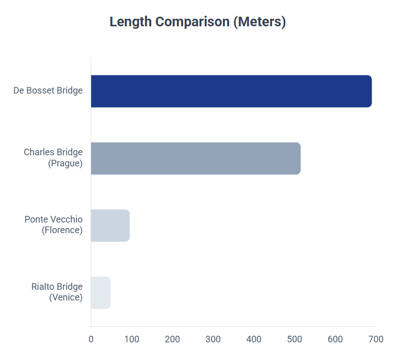
Table 2: Structural Specifications
| Feature | Detail | Context |
| Total Length | 689.9 meters | Connects Argostoli peninsula to Drapano coast. |
| Primary Material | Limestone / Sandstone | Quarried locally from Metela Hill. |
| Support System | 16 Arched Openings | Allows tidal exchange for Koutavos Lagoon. |
| Deck Surface | Paved Stone (Pedestrian) | Fully accessible, renovated 2005-2013. |
| Width | Restricted (Pedestrian) | Originally single-lane cart/car width; now foot traffic only. |
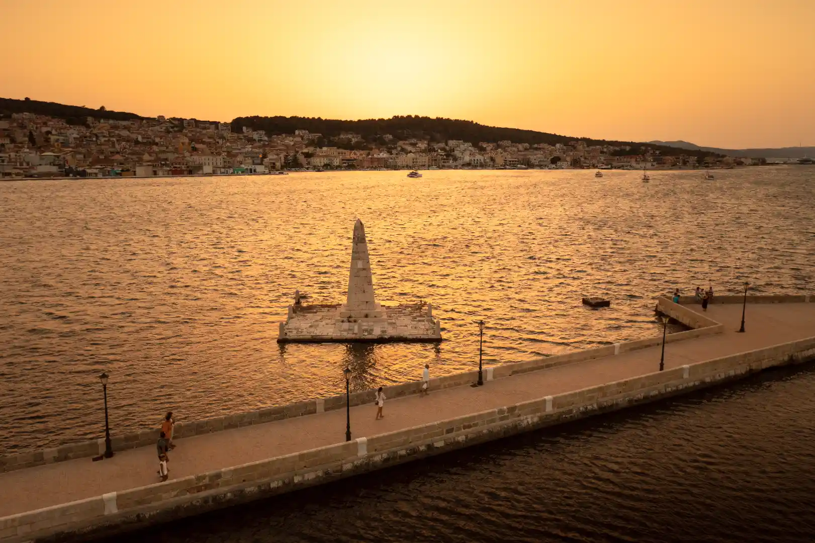
The Obelisk
Rising from the sea approximately halfway across the span is the “Kolona,” a four-faced symmetrical obelisk built on a square pedestal. It was Erected in 1813.
The “Missing Link”
Historical accounts and old lithographs suggest that a small stone walkway once connected the obelisk’s pedestal to the main deck of the bridge, allowing pedestrians to walk out and touch the monument.7 During the various reconstructions, particularly the post-1953 repairs or the recent restoration, this walkway was removed or lost. Today, the obelisk stands isolated in the water, a few meters from the bridge, accessible only to the sea birds that perch upon it. This physical separation enhances its mystique, turning it into an untouchable totem of the past.
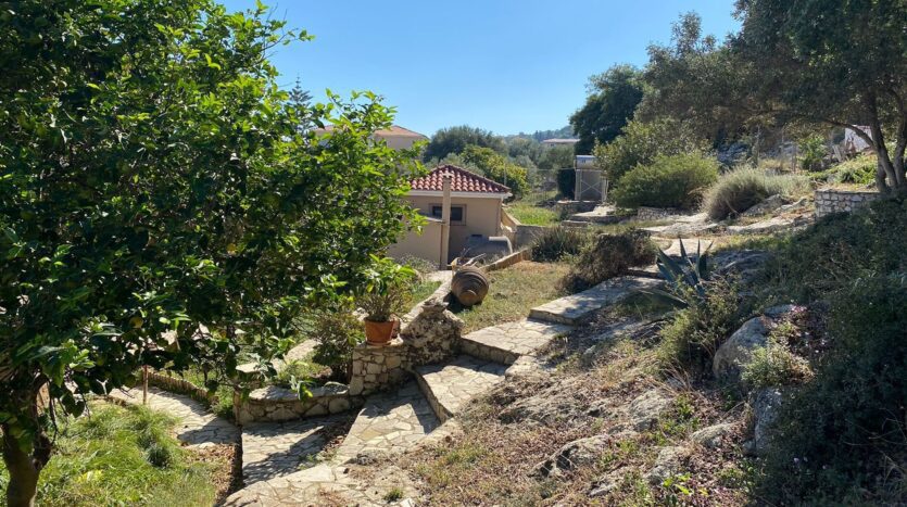
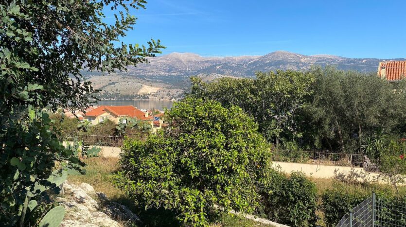
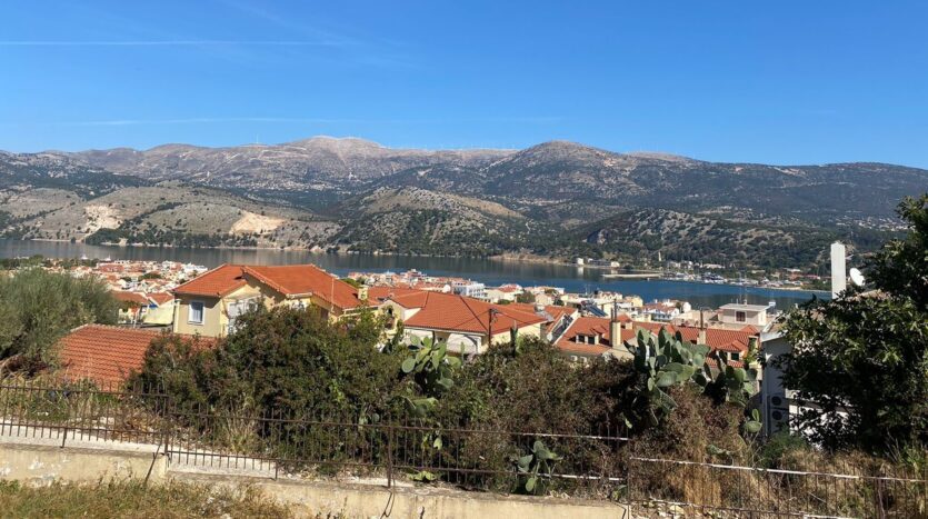
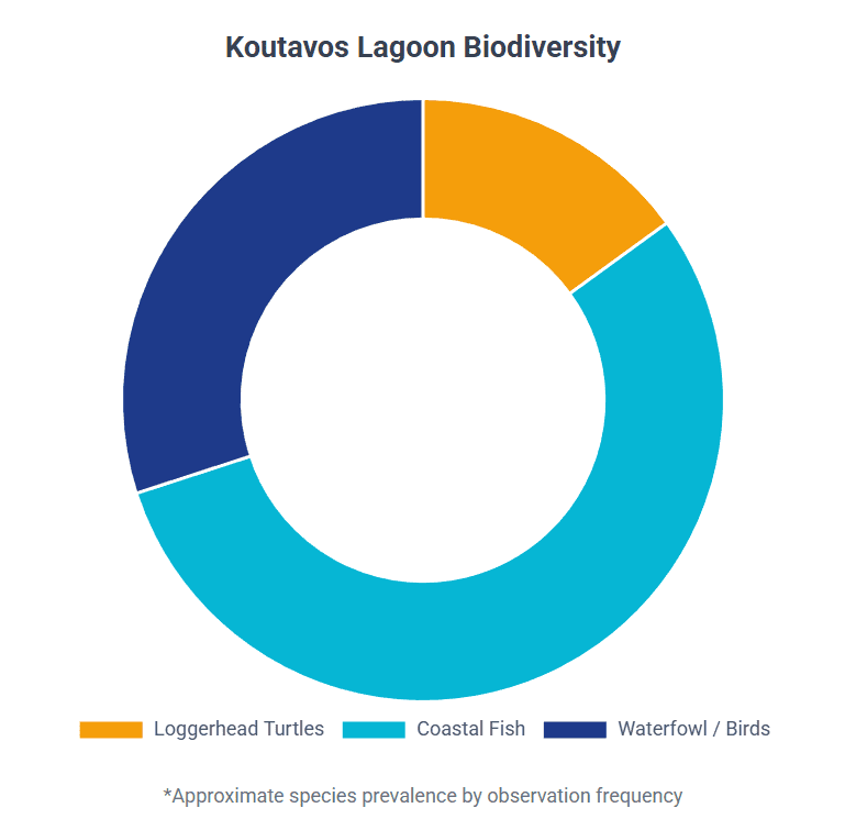
The Koutavos Lagoon: An Unintentional Sanctuary
The engineering of the De Bosset Bridge had an unintended but profound ecological consequence. By partially enclosing the head of the Argostoli Bay, the bridge created the Koutavos Lagoon, a shallow, calm body of water that functions as a distinct wetland ecosystem. While De Bosset feared the “stagnant waters,” modern ecology recognizes this semi-enclosed system as a vital nursery and feeding ground.
The Realm of Caretta caretta
The Loggerhead sea turtle (Caretta caretta) is the flagship species of Kefalonian conservation, and the De Bosset Bridge offers arguably the best non-intrusive viewing platform for this species in the Mediterranean.
- Behavioral Adaptation: Unlike turtles in the open ocean, the Koutavos population has adapted to the urban environment. They are heavily concentrated near the Argostoli harbor and the bridge, drawn by the presence of fishing boats. Local fishermen, cleaning their nets in the morning, discard bycatch and fish scraps into the water. This anthropogenic food source has created a semi-resident population of turtles that forage along the harbor wall and retreat to the calm, warm waters of the lagoon to rest and thermoregulate.
- The Bridge as Observatory: The bridge’s low profile and the clarity of the shallow water allow visitors to observe natural behaviors such as mating (in late spring) and foraging. Turtles are often seen swimming directly through the stone arches, navigating between the lagoon and the bay.
- Conservation Status: Organizations like Wildlife Sense monitor this population extensively. They use the bridge as a vantage point to track turtle numbers and health. The lagoon acts as a safe haven, protected from the heavy boat traffic of the main channel, although the interaction with fishing gear remains a threat.6
Avian Biodiversity and Flora
The Koutavos Lagoon is a designated wildlife sanctuary, crucial for the Ionian flyway. The bridge separates the deeper, saline bay from the shallower, brackish lagoon, creating a gradient of habitats.
- Resident and Migratory Birds: The lagoon supports a permanent population of Mute Swans (Cygnus olor), which nest near the reeds and are frequently fed by locals (though this is discouraged by conservationists). Beyond the swans, the area hosts Little Egrets (Egretta garzetta), Grey Herons (Ardea cinerea), and Black-headed Gulls (Chroicocephalus ridibundus). During migration, the lagoon becomes a stopover for waders like the Common Sandpiper (Actitis hypoleucos) and the Kingfisher (Alcedo atthis), which hunt in the seagrass beds.
- Benthic Flora: The seabed is carpeted with seagrasses (Cymodocea nodosa and Zostera noltei). These underwater meadows are the lungs of the lagoon, oxygenating the water and providing a nursery for juvenile fish and invertebrates (crabs, mollusks) that constitute the natural diet of the turtles and birds.24 The bridge’s arches are critical in maintaining the water flow that keeps these meadows healthy; without the tidal flush, the seagrass would die, leading to eutrophication.
Table 3: Key Species of Koutavos Lagoon
| Group | Species (Scientific Name) | Status in Lagoon | Observation Tip |
| Reptiles | Loggerhead Turtle (Caretta caretta) | Foraging/Mating (Endangered) | Look near arches/fishing boats (9:30-11:00 AM). |
| Birds | Mute Swan (Cygnus olor) | Resident | Nesting along reed beds; visible year-round. |
| Birds | Grey Heron (Ardea cinerea) | Resident/Wintering | Standing still on islet or shallow edges. |
| Birds | Kingfisher (Alcedo atthis) | Resident | Fast, low flight over water; bright blue flash. |
| Flora | Seagrass (Cymodocea nodosa) | Benthic (Seabed) | Visible as dark patches in clear shallow water. |
The Drapano Shore: A Journey into Silence
Crossing the bridge from the bustling capital brings the traveler to Drapano, a region that feels worlds apart. While Argostoli is the city of the living, Drapano is, in many ways, the village of memory.
The British Cemetery (Drapano Cemetery)
Located just 200-300 meters from the northern exit of the bridge, on the road toward Dilinata, lies the British Cemetery. This site is a poignant historical document carved in marble, offering a tangible link to the people who built the bridge and administered the island.7
- Demographics of Death: The cemetery contains the graves of British soldiers, administrators, and their families who died during the Protectorate (1809-1864). It also houses the remains of victims from the two World Wars.
- Notable Graves: One of the most emotionally resonant graves is that of Dr. Louis Charles Watkin, a British physician killed when the HMS Aurora was torpedoed in 1943. His epitaph, “Greater love hath no man than this, that a man lay down his life for his friends,” speaks to the sacrifices made in the defense of the Mediterranean.
- Artistic Value: The cemetery is not merely a burial ground but a sculpture park. It features elaborate monuments created by renowned Greek sculptors such as Georgios Bonanos and Dimitrios Filippotis. The “Sleeping Beauty” statue is cited as a work of exceptional beauty, reflecting the Neoclassical artistic currents of the 19th century. The juxtaposition of British names with Greek artistic mastery encapsulates the cultural hybridity of the Ionian Islands.
The Cyclopean Walls of Ancient Krani
For those willing to extend their walk, the Drapano side offers a gateway to deep antiquity. A hiking trail leads from the lagoon edge up to the hill of Ancient Krani, one of the four major city-states (the Tetrapolis) of Classical Kefalonia.
- The Walls: The site is famous for its Cyclopean Walls, massive fortifications dating back to the Mycenaean and Classical periods (7th-6th century BC). These walls are built of gigantic, polygonally cut stones, fitted together without mortar, an engineering feat that rivals the De Bosset Bridge in durability, having survived over 2,500 years of earthquakes.
- The View: From the heights of Krani, the hiker looks down upon the De Bosset Bridge. This perspective offers a powerful visual timeline: the Mycenaean walls in the foreground, the British colonial bridge in the middle ground, and the modern Greek city of Argostoli in the distance. It is a rare location where three distinct eras of civilization can be taken in a single glance.
The Visitor Experience: A Sensory Guide
The “Volta”: Atmosphere and Lighting
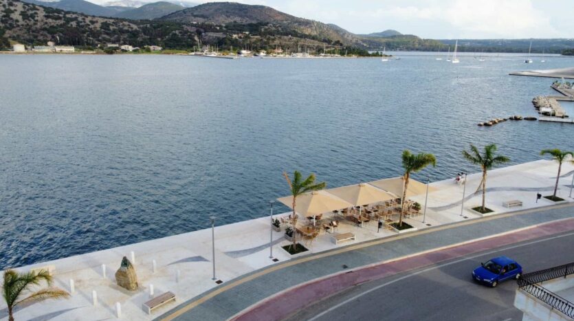
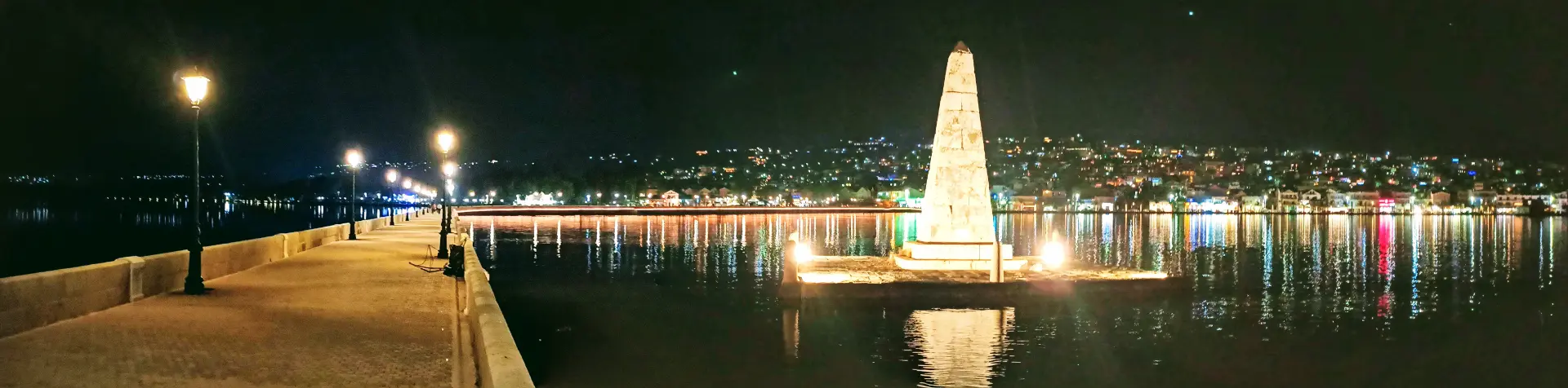
In the cool of the evening, the De Bosset Bridge reclaims its function as a social stage. It is a prime location for the volta, the traditional Greek evening promenade. The restoration installed a series of elegant, lantern-style streetlamps along the entire span.
- The Lantern Effect: At night, these lamps cast a warm, golden light that reflects off the still waters of the lagoon. The reflection often appears as a series of “starbursts” on the water’s surface, creating a magical, almost theatrical atmosphere.
- Aural Landscape: With cars banned, the soundscape is defined by the lap of water against the stone piers, the call of night herons, and the murmur of conversation. It is a place of quietude, contrasting sharply with the scooter-filled streets of Argostoli.
Walking Itineraries
Route A: The “Sunset & Turtle” Stroll (Leisure)
- Best Time: 1 hour before sunset.
- Duration: 45 minutes (one way).
- The Path: Start at the Argostoli waterfront. Walk slowly, scanning the water on the lagoon side (east) for turtles surfacing. Pause at the Obelisk to watch the sun dip behind the Fanari hills. The golden hour light illuminates the limestone, turning the bridge a warm honey color, ideal for photography.
- End Point: Turn around at the Obelisk or continue to the Drapano shore for a quiet moment before returning under the lit lanterns.
Route B: The “History & Heritage” Trek (Active)
- Best Time: Morning (starts 9:00 AM).
- Duration: 3-4 hours.
- The Path: Cross the full length of the bridge. Visit the British Cemetery to pay respects and admire the sculpture. Return to the lagoon edge and follow the “Koutavos Loop” trail south. Locate the path to Ancient Krani near the old aqueduct/pumping station. Hike up to the Cyclopean Walls for the panoramic view.
- Gear: Sturdy shoes are required for the Krani section (uneven terrain). Water is essential as there is no shade on the bridge or the ruins.30
Practical Information for the Traveler
| Feature | Detail | Note |
| Access | Pedestrian & Cyclist Only | Wheelchair accessible (flat paved stone). |
| Admission | Free | Open 24/7. |
| Parking | Argostoli Harbor or Drapano | Drapano side often has more space in peak summer. |
| Facilities | Benches along span | No toilets/water on the bridge itself; cafes at Argostoli end. |
| Photography | Wide angle + Telephoto | Wide for the bridge curve; Telephoto for turtles/birds. |
Conclusion: The Bridge as Living History
The De Bosset Bridge is a survivor. It has withstood the tectonic rage of the Earth, the aerial bombardments of World War II, and the slow corrosion of time. Its transformation from a wooden military supply route to a stone monument, and finally to a pedestrian sanctuary, mirrors the evolution of Kefalonia itself. It has moved from a place of strategic necessity to a place of leisure and ecological contemplation.
For the modern visitor, the bridge offers a profound connectivity. It connects the traveler not just to the opposite shore, but to the vision of Charles de Bosset, the craftsmanship of the stone masons of Metela, the silence of the British soldiers in Drapano, and the ancient resilience of the sea turtles below. In a world of fleeting digital experiences, the De Bosset Bridge remains a creature of stone and water-solid, enduring, and undeniably real. It is, as the records state, the longest of its kind, but its true length is measured not in meters, but in the centuries of history it spans.